


San Jacinto Peak is the highest peak in the San Jacinto mountain range at 10,834 feet of elevation; and the second tallest mountain in Southern California. It is also the sixth most topographically prominent peak in the contiguous United States.In the past, San Jacinto was known to the Cahuilla Native Americans as Aya Kaich, meaning an area with smooth cliffs. To them, the mountain was the home to Dakush, the meteor and legendary founder of their tribe. Today, San Jacinto is known to hikers and mountaineers as one of the “Three Saints”, a term that refers to the three tallest mountain ranges in Southern California – the San Jacinto Range, the San Gabriel Range, and the San Bernadino Range. The other mountain members of the Three Saints are Mount San Antonio, and Mount San Gorgonio. The mountain has also been popular with modern explorers and conservationists, including John Muir, who stated, “The view from San Jacinto is the most sublime spectacle to be found anywhere on this earth”. The mountain is also a popular destination due to its proximity to Southern California, and has multiple points of access on both its Eastern flank (Palm Springs) and its Western Side (Idyllwild).
Suicide Rock
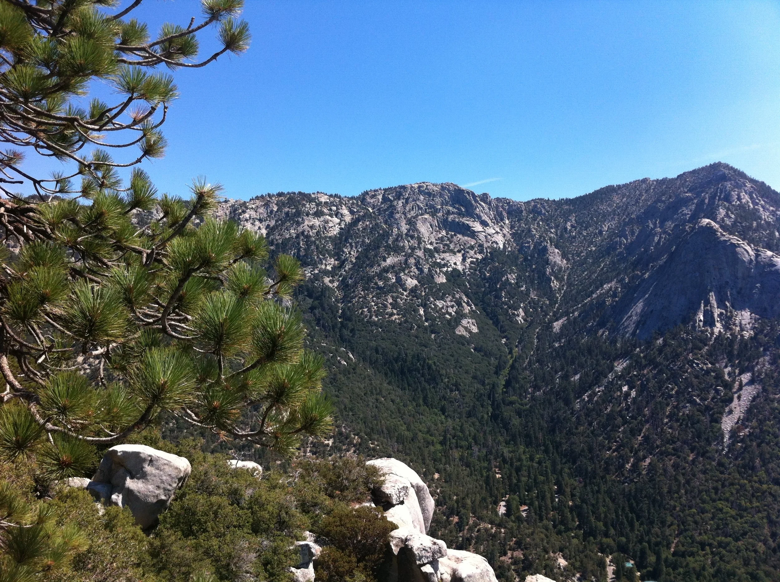
One of the things most people don’t realize about Southern California is that while we do have beaches and deserts, we also have mountains – and those mountains have a number of great spots for hiking. Idyllwild, California, is a small mountain town that is close to both Los Angeles, and San Diego; it is located on the Western side of Mount San Jacinto, and can be utilized as a jumping off point to climb the mountain; and is also a great spot to go day hiking in or around the city year-round. While I love climbing San Jacinto, and have done so many times, it is a strenuous climb, and is one that is not for everyone. Fortunately, in this case, you don’t have to be a climber to get a great view of Idyllwild, and the surrounding portions of San Jacinto State Park and the San Jacinto – Santa Rosa National Monument as these views can be seen from the best day hike in the area, Suicide Rock.
Current Conditions, Deer Springs Trail/San Jacinto, December 30, 2012
There’s a number of ways to celebrate the end of the year. For some, it’s all about wearing green underwear, eating twelve nuts, twelve grapes, and packing a bag to leave at home. For others, it’s the typical night out extravaganza in around the world style, followed up by watching bowl games for the entirety of the first day of the year in a near comatose state. For me, I like to try and get out at least once at the end of December. It helps me feel like I haven’t become the blob after eating oodles of home-made Peppermint Bark and other delicacies throughout the Thanksgiving to New Year’s Eve period. Getting out at the end of the year is tricky – sometimes it feels like the only place you get to is the mall; but, I always find it worthwhile because it allows me to recharge my batteries, appreciate the beauty of winter, reflect on the year past, and set goals for the coming year.
Long Valley to Folly Peak to Mt. San Jacinto (2011)
Round Valley, April 2011 (less snow here than May 2010!)
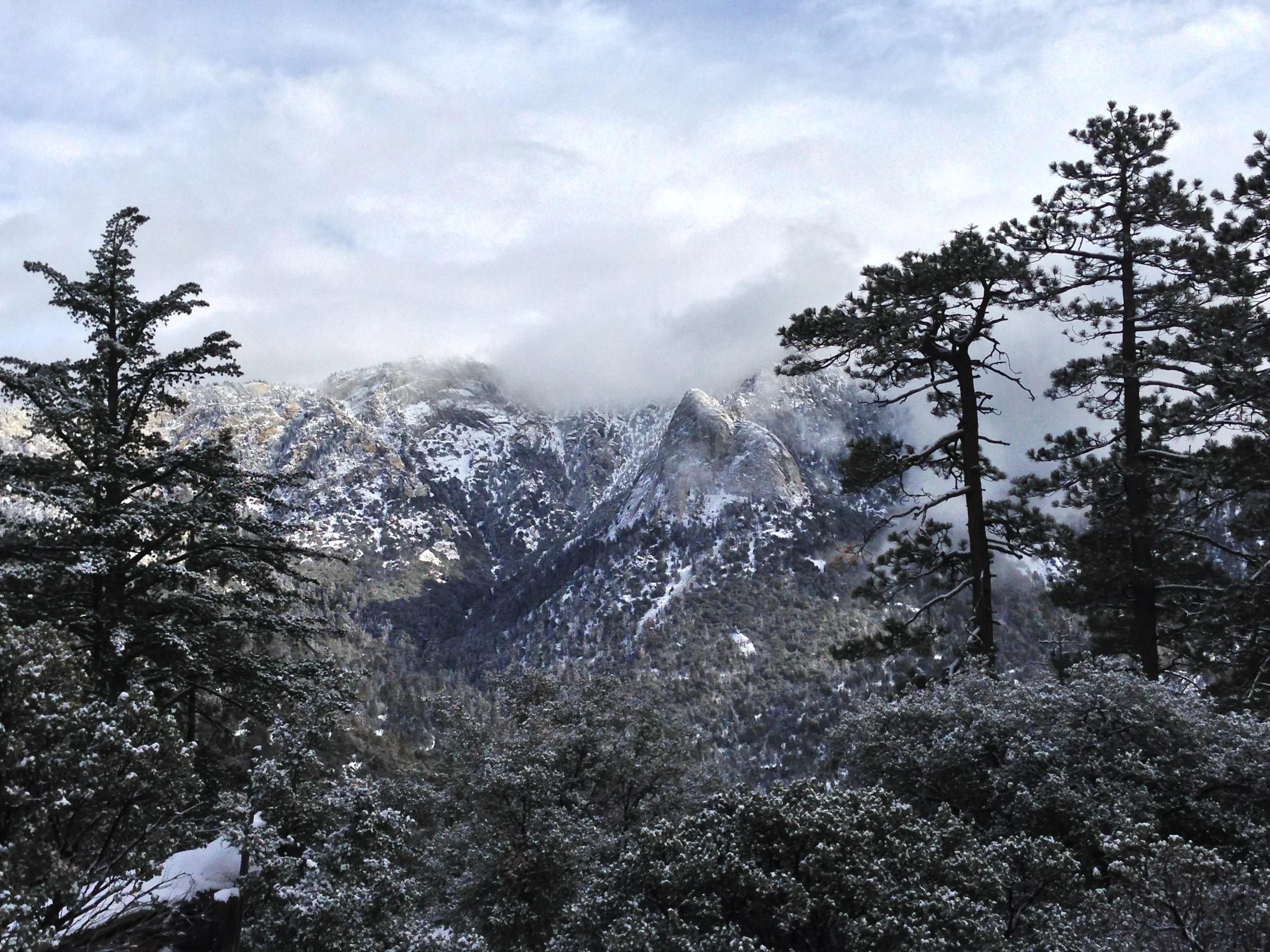
Although the backcountry skiing on San Jacinto is superb, what I like most about the peak is climbing it in winter. In fact, I’d go so far as to say that I prefer climbing the peak in the winter months over the summer months. While I have nothing against the summer route – and standard route that you loosely follow in the winter – I’d say the winter approach is a lot more fun. For starters, in the winter, you will likely have to find your own route after a certain point depending on the snow; there are less people; and in my opinion, the mountain is more scenic with a coating of ice and snow than it is in the summertime. There’s also no risk of dealing with extremely hot temperatures, dust; and if the conditions are right, you can glissade down the face of the mountain, which is a great rush, and an enormous time saver. I always make a point to head up to the summit of San Jacinto once a year (just to make sure it’s still there); and for the past two years, I’ve had great bluebird days on the peak in winter. As I’ve discussed the last two days, the snow this year is not what it has been, but I am sure I will head up to the summit at some point in the near future. From what I hear, you will still need crampons/microspikes at this point, even though the snow conditions are not optimal.
Folly Peak to San Jacinto summit traverse (2011).
Directions: The easiest – and most accessible route is the same route that you would take in the summertime. The route starts from the Palm Springs Aerial Tram station in Long Valley. From the tram station, head into Long Valley, where you will pass the Ranger Station within a quarter mile. Remember, you will need a permit to head any further – but, don’t despair – permits are free! From the Ranger station, you will head up the trail (if it is visible) to Round Valley. At this point, where you head is a matter of where you want to go, and how your orienteering skills are. In 2010, I kept my group fairly close to the route of the actual trail (even though it was several feet below us in the snow); and in 2011 I elected to take my climbing partner and I up the face of Folly Peak after we branched off at Wellman’s Divide.
Alternatively, one could head straight for the summit prior to or at Round Valley; but in my opinion, the Folly Peak to San Jacinto traverse in winter is the way to go. Folly Peak is directly to the West of the San Jacinto summit; and clocks in at 10,480 feet. Last year, we traversed up to its summit in some fairly soft powder that was warming in the mid-afternoon sun. Once we were at the summit of Folly, we followed the more packed snow on the ridgeline over to the actual summit of San Jacinto, which was a little less than a mile. To get back to the tram, you can either walk back the way you came, or, if the conditions are right, like they were last year, you can glissade back down into Round Valley. This is exactly what my climbing partner and I did; we traversed back down to the rescue hut, and after checking it out – and the log, found a great spot to glissade down. I’d estimate that this way eliminated about two to three miles from our return trip; and was great fun, but there has to be enough snow to take this route (which at this point in 2012, it appears there is not). Distance wise, you can make this winter summit bid last around twelve miles if you really want, but realistically, if you know how to use a map and compass, or GPS, you’re looking at much less distance.
Summit, San Jacinto, 2011
San Jacinto summit, looking North to San Gorgonio
Tips: As noted in the last post, you’ll want the proper gear for this, in case the tram stops running; and because you are winter mountaineering. The summit does get hit pretty hard by strong winds, and the temperature can drop very fast. If you are going to attempt this in wintertime, I’d recommend one heads out mid-winter, rather than late winter. The difference? Firm footing that will involve less postholing than melting snow offers. If you are going to attempt this, do be familiar with your map/compass/GPS so as not to get lost. And finally, do note that John Muir did indeed say, “The view from San Jacinto is the most sublime spectacle to be found anywhere on this earth!” While I hate to disagree with Muir overall, what I will say is that if you do climb the peak in winter, you will definitely have a more sublime experience than the summer!
See you on the trail!
And...a view from the summit, here: http://youtu.be/uAwr5sMeW5A
More Information: http://www.parks.ca.gov/pages/636/files/MtSanJacintoSPmap.pdf, http://www.peakbagger.com/peak.aspx?pid=1480, http://angeles.sierraclub.org/hps/guides/27F.htm, http://www.summitpost.org/folly-peak/300638, http://en.wikipedia.org/wiki/San_Jacinto_Peak, http://lastadventurer.com/last-adventurers-fieldnotes/2010/6/6/san-jacinto-tram-to-summit-may-31-2010.html
Current Snow Conditions on Mt. San Jacinto, January 2012
San Jacinto, 01/22/12 - not much snow!
Yesterday was basically a 1980's adventure revival day as I stopped at the Cabazon Dinosaurs (http://lastadventurer.com/last-adventurers-fieldnotes/2012/1/23/cabazon-dinosaurs.html) and headed up the Palm Springs Aerial Tramway for a little hiking. There's nothing really retro - or eighties about the tram these days, as it's a slick, modern rotating machine, but when I got to Long Valley, I had a very retrofabulistic moment (yes, I know retrofabulistic isn't a real word, but it sounds good, right?) when I looked around, and there was almost no snow. At that moment, my exact thoughts were: "Where's the snow?!?!?" As you can see from the photos, there was little to no snow at around the ~8500 foot mark that Long Valley sits at. As I walked along the valley, both East and West, I'd say the snow depths were running at ~1-3 inches, variable, mostly melted off, and what base layer remained was almost completely iced out. Keep in mind that these conditions were after the "winter" storm we received in the Southern California region, which obviously left no accumumulations at this elevation. From Long Valley up to Round Valley, there was spotty accumulation, mostly under deep tree cover and around the rocks of ~2-4 inches, variable; with an occasional "drift" of a foot or more (again, completely iced out). More often than not, even up to around ~9500 feet, there were bare spots of dirt, and no snow coverage whatsoever.
San Jacinto, 01/22/12 - where's the snow?!
This is in start contrast to last year, 2011, when I was on the summit in April, and there was still a substantial amount of snow from Long Valley on (several feet), and from 2010 when I headed up the to the summit on Memorial Day in several feet of snow from Long Valley. While a storm is passing through today, the ten day shows nothing but sun. At this point, it looks like we will be experiencing a drought year, which, while good for peakbaggers, is bad for fire conditions. If you are planning on heading for the summit at this point, I'd strongly recommend microspikes/crampons due to the prevalance of ice on the trail and summit approach.
Pray for snow!
More Information: http://www.parks.ca.gov/?page_id=636, http://mtsanjacinto.info/viewforum.php?f=1&sid=6fa45979eed52ba5ffc35100ff9cc233
San Jacinto Tram to Summit, May 31, 2010
Syrio and RB debate water treatment options in Round ValleyDown in the valley, I could see the desert smog-haze smoking in the mid-day sun. Around us, I saw people looking at our gear with quizzical expressions. Five feet away from us, I saw the third shuttle heading up to the tram station. Behind me, I could hear Rude Boy (“RB”) cursing at his shoe. I smiled. It wouldn’t be an expedition without problems. I turned around, and saw that RB was actually cursing at his shoelaces, which were now lying in several unraveled pieces, rather than his shoes. Calmly, I put my pack back down in the parking lot next to Syrio and Jaime, and quipped to RB, “You know, when I said I’d teach you the ways of the ninja mountaineer, this wasn’t quite what I had in mind.”
It was Memorial Day, and the four of us were at the parking lot just below the Palm Springs tram shuttle. We had made it there by overcoming our holiday weekend inertia, a leaky ceiling, crappy traffic on the I-215, and a slew of preparatory e-mails. We had come to Palm Springs not to ride the incredible spinning tram with everyone else, but to hopefully bag the peak. Really, bagging the peak was the secondary objective in my mind; the primary objective was to see how half of the group handled snow, ice, and other mountaineering challenges prior to climbing Whitney. That’s right. Whitney. I was going back to lead another group. Clearly, either there was some unfinished business there, or I was a slow learner, or maybe the mountain had some sort of subliminal subconscious pull in my mind. In 2007, I had led my second group up Whitney in October, the “First and Last Pizza Port Mountaineering Expedition”, and had placed five out of six people on the summit. (http://last-adventurer.squarespace.com/last-adventurers-fieldnotes/2008/1/2/the-first-and-last-pizza-port-mountaineering-expedition-day.html)
After that expedition, a myriad of things happened, and I could spend a million words discussing each of them, but for now, the pertinent information is that I was going back to Whitney, this time in the summer of 2010 with a new group of eight, in the “Who Dares Wins” expedition. I was going to make sure the group was as ready as they could be. This is why I was at San Jacinto, on a perfect blue sky holiday Monday. If you’ve never been, the Palm Springs Tram leaves the desert valley floor at 2500 feet, and heads up to the station at 8500 feet near the San Jacinto summit. It’s probably the easiest way to climb 6000 feet I’ve ever experienced; and according to the promotional material, it is the largest rotating aerial tramway in the world. (http://www.pstramway.com/).
Since the sun was rolling across the sky, I sized up the shoelace situation, and applied some master ninja mountaineering powers to the problem. Since mountaineering boots come with standard extra long laces, I cut off the surplus, and knotted them together into one new super-lace with which RB was able to use to tie his shoe. With that crisis solved, we were able to catch the tram and hit the trail at the top. The San Jacinto summit trail curves in a giant “U” from the tram station, through Long Valley, and then up into Round Valley, switchbacks, and then the summit. We acquired our permit from the Ranger Station (free), and began the ascent with lots of energy. As we headed up the trail, I was surprised to see that the upper reaches of the slopes were partially covered with large drifts of snow.
The amount of snow was surprising, because several years back, I had climbed Jacinto a week before Memorial Day, and entirety of the hike had been bone dry. I wasn’t going to complain, however, since I wanted the group to get some snow and ice experience. By the time we had reached Round Valley, they had definitely obtained a fair amount of experience, as the conditions had gone from partial coverage of two-foot drifts, to total coverage. I ski Jacinto yearly in the dead of winter, so I wasn’t concerned about getting lost, however, for a short period of time coming into Round Valley, the trail had disappeared under the snow, causing me to orienteer a route to the Ranger Station at Round Valley.
Summit, 5/31/10
After taking a short break, we continued up toward the peak, only to lose the trail completely at around 9200 feet. Based on my recollection, and my compass skills, we cut across the now completely snow covered terrain to the base of the final summit ascent, where we picked up the trail on again on the switchbacks. The switchbacks were partially melted out, and by that time of the day, the snow was quite slushy, and we post-holed in numerous spots where the drifts still existed. Shortly before the hut, the trail was completely obscured by snow, but we powered on to the summit. On the decent, as it was quite late in the day, there was a fair amount of melting going on, and more post-holing, but as a bonus, we were able to pick up the main trail and follow it back completely, rather than following the route we had marked. It took us a little over seven hours, roundtrip, and by the end of the day, everyone had gained a substantial amount of experience. Overall, it was a great time, and I thought the group did a great job dealing with the adversity that we faced that day. Also, if anyone’s heading to Jacinto in the next couple of weeks, be aware that winter conditions still exist, even though it is now mid-June. See you on the trail!
Lots of snow for the end of May, 2010!