Irrespective of whether you’re a native Californian whose recently become interested in the outdoors, or a recent transplant that’s been hiking for years, you’ll find that San Diego has a number of fantastic trails and hiking opportunities.
As you’ve seen above, #preservethegood could mean anything – it could mean helping someone in a time of need; it could be picking up trash on a trail, or a wilderness area; it could be educating people on leave no trace principles; it could be making a difference in any way you want; and it could be just about anything you want as long as you are focused in keeping the magic and the unique positive things in this world and this life. In terms of tangible things, I encourage you, my readers and followers to use the hashtag when you post a photo of something amazing; or when you’re talking about something exceptional you – or someone else has done to improve the world. I look forward to seeing how all of you end up preserving the good in 2015, and you can rest assured that as always, I will keep preserving the good where I find it as well, because as Plato says, “Good actions give strength to ourselves and inspire good actions in others.”
As I mentioned previously, Waimea Canyon is a site that is most definitely one of the “must-view” locations on Kauai, and in the world; and as I also mentioned, the best way to experience it is to hike it. While there are many great hikes through the canyon, the best hike in my book is the Canyon Trail to Waipoo Falls. It is the best hike to me because at four miles roundtrip, it is accessible, it has stunning views of the canyon from inside the canyon, and it ends at the top Waipoo Falls. It also allows the hiker the chance to swim in a waterfall, which is a once in a lifetime experience.
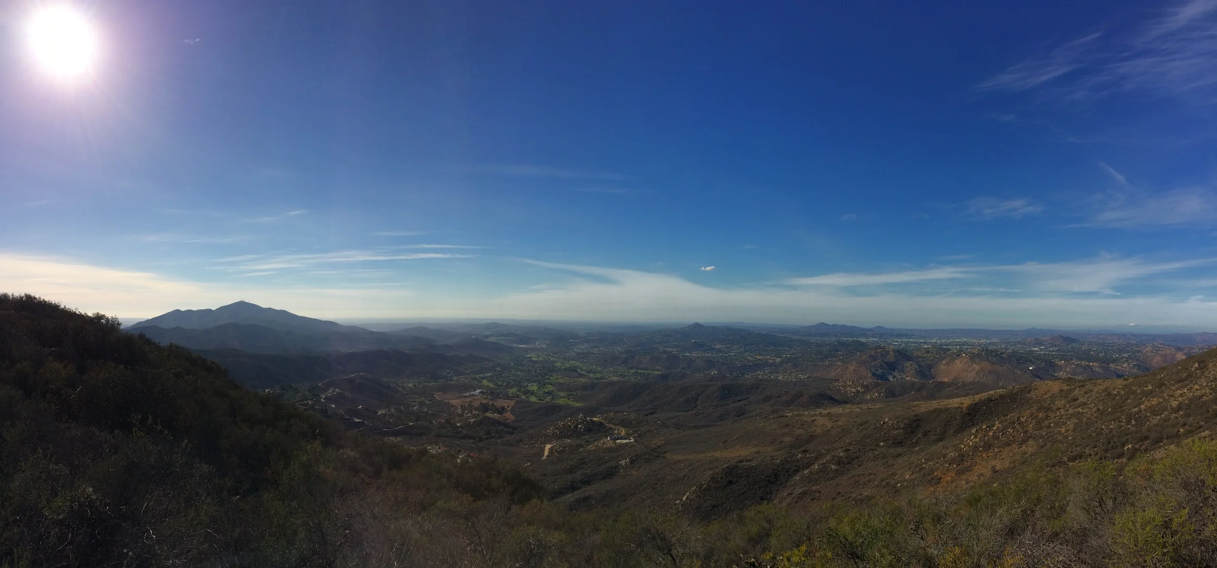
San Diego is a spot with many great hiking trails. In fact, saying that San Diego has “many” great hiking trails sells the city short; the reality is that San Diego has a plethora of great hiking spots. I can think of no other location in the United States where the beach, canyons, hills, mountains, and deserts are all within a two hour drive; and in some cases are within a one-hour drive. San Diego is also a spot where many household names – Iron Mountain, Cowles Mountain, Torrey Pines, the Devils Punchbowl, and the Three Sisters are hiking trails. In this blog, I’ve discussed my opinions about these places and I’ve also discussed other great hiking spots; but what I will say positively about these trails and their popularity is this: they get people outside. In my experience, when people get outside, they’re more likely to learn things; they’re more likely to boost their endorphins; and they’re more likely to want to protect not only where they went, but other wilderness areas as well. So yes, these trails are popular, as I’ve discussed, but sometimes, popularity is not all bad.
Case in point: McGinty Mountain – or Mt. McGinty. Like Iron Mountain, the roundtrip distance of this hike is 4.8 miles, and the while the elevation gained is slightly less, Mt. McGinty has two advantages: more rare plants and….a lot less people. Advantage: Mt. McGinty. Moreover, Mt. McGinty also has something Iron Mountain does not: hidden mines. Advantage again: Mt. McGinty. So, if you’re interested in a peakbagging experience in San Diego county that does not involve lots of hikers, read on.
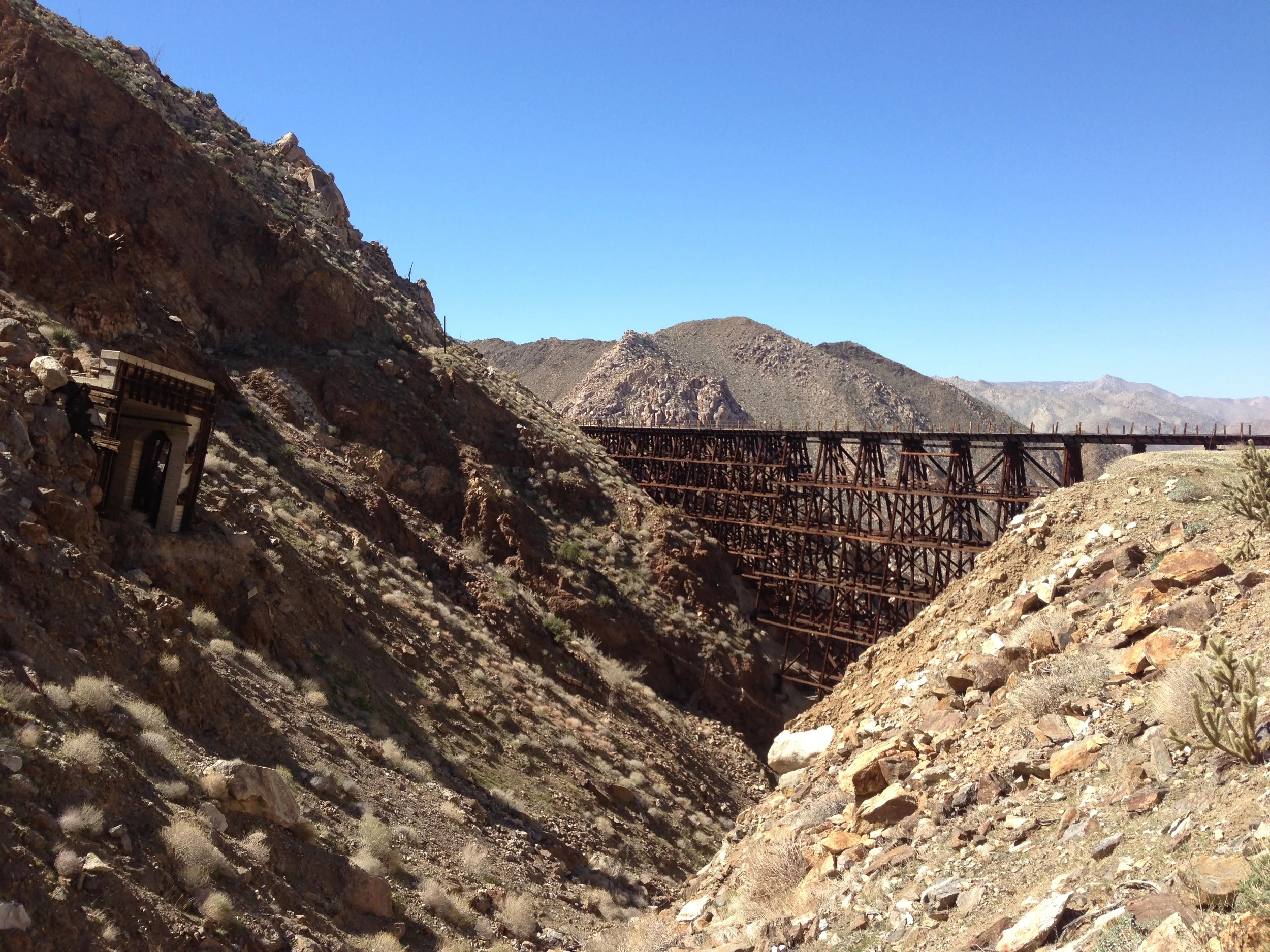
Fact: the best hike in San Diego County is one that most people aren’t going to want to do, and probably shouldn’t do, unless they are physically and mentally prepared. And, even better, here’s a supplemental fact about this hike: I had so much to say about this hike that I had to break up my comments into two posts. This hike involves traveling over rough terrain. It involves using a map and compass, or GPS unit. It involves scrambling and some bouldering. It involves not following a trail. It involves off-roading to a remote trailhead; and it involves committing a whole day to hiking in and hiking out. It involves exploring, and possibly breaking the law. It involves avoiding glowing orbs, and avoiding the Borrego Sandman (or men), if they exist. In short, the best hike in San Diego County is nothing short of an epic one-day adventure. This is precisely why this hike is the best hike in San Diego County: it is an adventure. What hike are we talking about? What I am talking about is the Goat Canyon Trestle Hike to the Carrizo Gorge, or if we are being formal, the Mortero Palms to Goat Canyon Traverse.
Today I’d like to talk about the myth and legend of the “Devils Punchbowl” in San Diego County. If you’ve like me, and you’ve lived in San Diego, or spent enough time in San Diego, and you’re interested in the backcountry, chances are you’ve heard of “The Devils Punchbowl” after you heard about Cowles Mountain, Iron Mountain, and Woodson Mountain (a/k/a “Potato Chip Rock”). Here’s the interesting thing though: unlike the above peaks, “The Devils Punchbowl” is a more nebulous concept. There’s no doubt that it exists – it’s definitely a location that exists. But, it exists in about ten or eleven different locations, depending on who you are talking to, and who is giving you directions to the “actual” site.
While San Diego County has a plethora of great hiking trails, it does not have a lot of great climbing routes. Sure, there’s some decent routes out in the desert, but realistically, no one wants to be out in the Anza Borrego desert in the dead of summer. In no particular order, some of the better places to climb in the county are on the boulders at Woodson Mountain; the summit slabs at Stonewall Peak; the final approach on Mt. Lawson; and the routes at Mission Trails Regional Park.
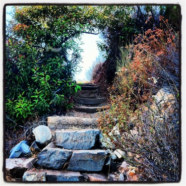
Steps, Climbers Loop Trail
While none of these routes are going to confuse anyone with say, Half Dome, El Capitan, or any other big wall on the planet, they’re great areas for learning and practicing your climbing skills that aren’t in a controlled environment (otherwise known as climbing gyms). All of these areas have great hikes leading to the climbing areas, but this hike is the shortest and steepest of the bunch.
Directions: The best way to access this trail is to park at the Mission Trails Regional Park Visitor Center, which is located in the main portion of the park off of Mission Gorge Road. Even though Cowles Mountain is not located in this part of the park, parking remains at a premium on the weekends by the Visitor Center, due to the popularity of the area, and its proximity to a number of trailheads. While there is some parking along Father Junipero Serra Trail, the road that runs through Mission Trails, these spots are usually taken as well by mid-day.
From the Visitor Center parking area, you will want to head down Father Junipero Serra for .40 miles. During this short distance, I would suggest that you take the opportunity to enjoy the paved, flat surface and stretch out any kinks you have in your legs, as the actual trail has few flat sections, and is most definitely not paved! At .40 miles, you will see the trailhead on the right (south) side of the road, along with a kiosk detailing the steep terrain on the trail, and various climbing routes present on the Western face of Kwaay Paay Peak. From this point, the trail ascends steeply for .34 miles. How steep is it? Well, it ascends 406 feet over that distance, so while it isn’t the steepest terrain imaginable, it’s not a walk in the park either. Once you have ascended the 406 feet, you will have great views of Mission Trails, Mission Gorge, and the climbing routes.

Climbing Routes, west Kwaay Paay Peak
Based on my experience, if you are climbing any of the routes on the western face – Middle Earth, Limbo, or the main wall, you will definitely be warmed up and ready to go by the time you reach the “top”. If you’re not climbing, continue on along the mostly flat section of trail leading past the climbing areas, before descending down another steep section of trail. If you are solely hiking this area, the total distance for this hike is 2.2 miles roundtrip (.4 from the parking area to the trailhead, 1.2 miles on the actual trail, and .6 from the far trailhead back to the parking area).
Tips: I personally like to run this trail on weekdays. The steep terrain is very challenging, and gives you a great workout. Unlike Cowles Mountain, it is also not as busyduring the week. Do note, however, that the trail is very steep, and what I would consider “single track” in many areas. Keep an eye out for other hikers, as well as climbers carrying gear so you do not potentially run into them. Aside from that, the routes on the western face of Kwaay Paay Peak are not that technical, so they are a great area to learn how to climb if you do not; and many companies provide lessons on a weekly basis at this location. Even if you do not wish to climb, this is a hike with some great views of the surrounding terrain, and if you’re curious about climbing, good views of climbers doing what they do: climbing.
The third confession that I have for my readers this week is not a confession, it’s a fact. Fact: Iron Mountain is the second most popular hike within the confines of San Diego County. The only thing that makes Iron Mountain the second most popular hike within the county is that at six miles roundtrip, it is a big longer than the first most popular hike within the county, Cowles Mountain. If you are looking for solitude on your hike, do not hike Iron Mountain. Well, ok, I shouldn’t say that. If you hike Iron Mountain in the middle of the night or on a rare rainy, cold day in San Diego, you might be alone on the trail. You might. Even under those conditions, I’d still assume that you’d run into at least one person. Iron Mountain is the second largest peak in the city of San Diego proper at 2,696 feet; and it is in the portion of the county with a number of hiking trails, such as the Goodan Ranch-Sycamore Canyon Preserve, and Woodson Mountain. Unlike Woodson, I’d recommend Iron Mountain as a hike, as it’s a great hike or jog; and when you get to the summit, you will have great unobstructed views of the surrounding area; however, do bear in mind that if you are indeed seeking solitude, this is not the hike for you.