

The Route from Mortero Palms Trailhead to the Goat Canyon Trestle: As I said yesterday, there is no “trail” that leaves the Mortero Palms Trailhead and takes you directly to the trestle. The best description (other than one’s found online) that I’ve ever read is in Jerry Schad’s Afoot and Afield, which as I’ve said before, is the bible of San Diego County Hiking. This is the route that I followed; and the route that I’m going to describe here in the next several paragraphs and pictures. As there is no “set” route, keep in mind that my directions here should be not taken as the gospel truth and that if you go, you should take a GPS and or map and compass in order not to get lost. Finally, in case you want more information (which is good); check out these trip reports here, here, here and here. I always say that more information is better, especially for a hike like this where there is no trail. And with that in mind, here we go!
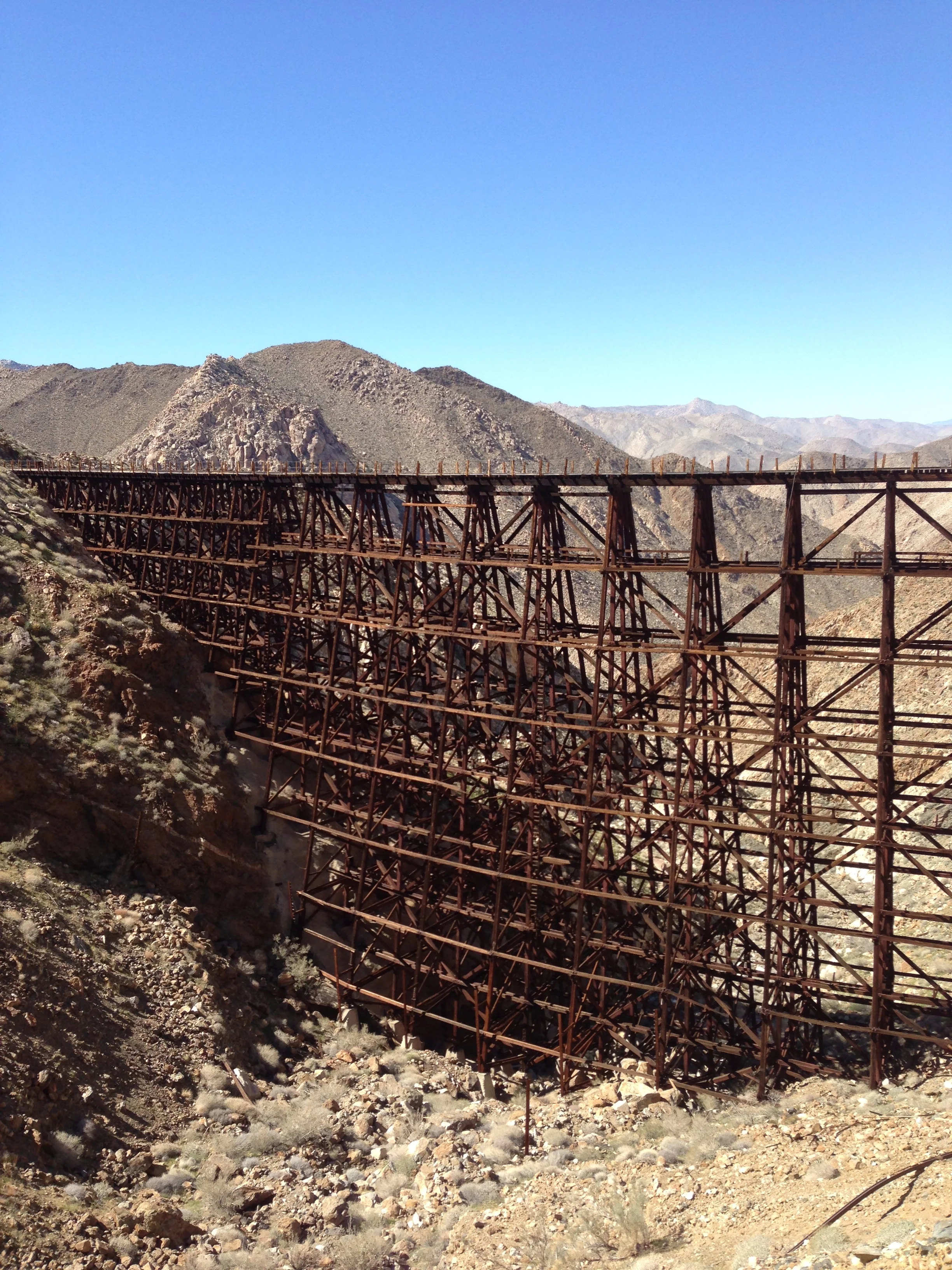
Background on the Infamous Goat Canyon Trestle Hike
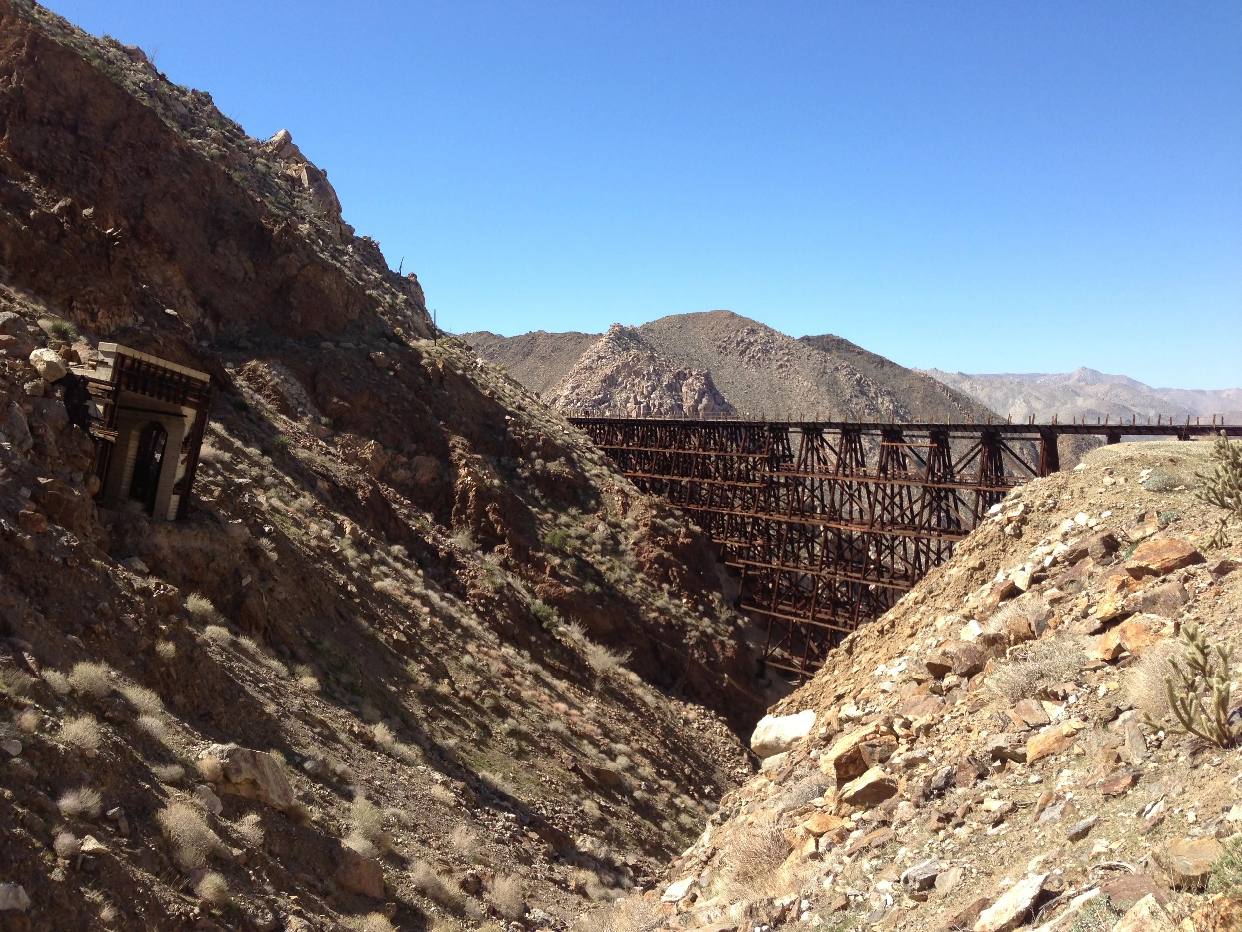
Fact: the best hike in San Diego County is one that most people aren’t going to want to do, and probably shouldn’t do, unless they are physically and mentally prepared. And, even better, here’s a supplemental fact about this hike: I had so much to say about this hike that I had to break up my comments into two posts. This hike involves traveling over rough terrain. It involves using a map and compass, or GPS unit. It involves scrambling and some bouldering. It involves not following a trail. It involves off-roading to a remote trailhead; and it involves committing a whole day to hiking in and hiking out. It involves exploring, and possibly breaking the law. It involves avoiding glowing orbs, and avoiding the Borrego Sandman (or men), if they exist. In short, the best hike in San Diego County is nothing short of an epic one-day adventure. This is precisely why this hike is the best hike in San Diego County: it is an adventure. What hike are we talking about? What I am talking about is the Goat Canyon Trestle Hike to the Carrizo Gorge, or if we are being formal, the Mortero Palms to Goat Canyon Traverse.
Arroyo Tapiado Mud Caves
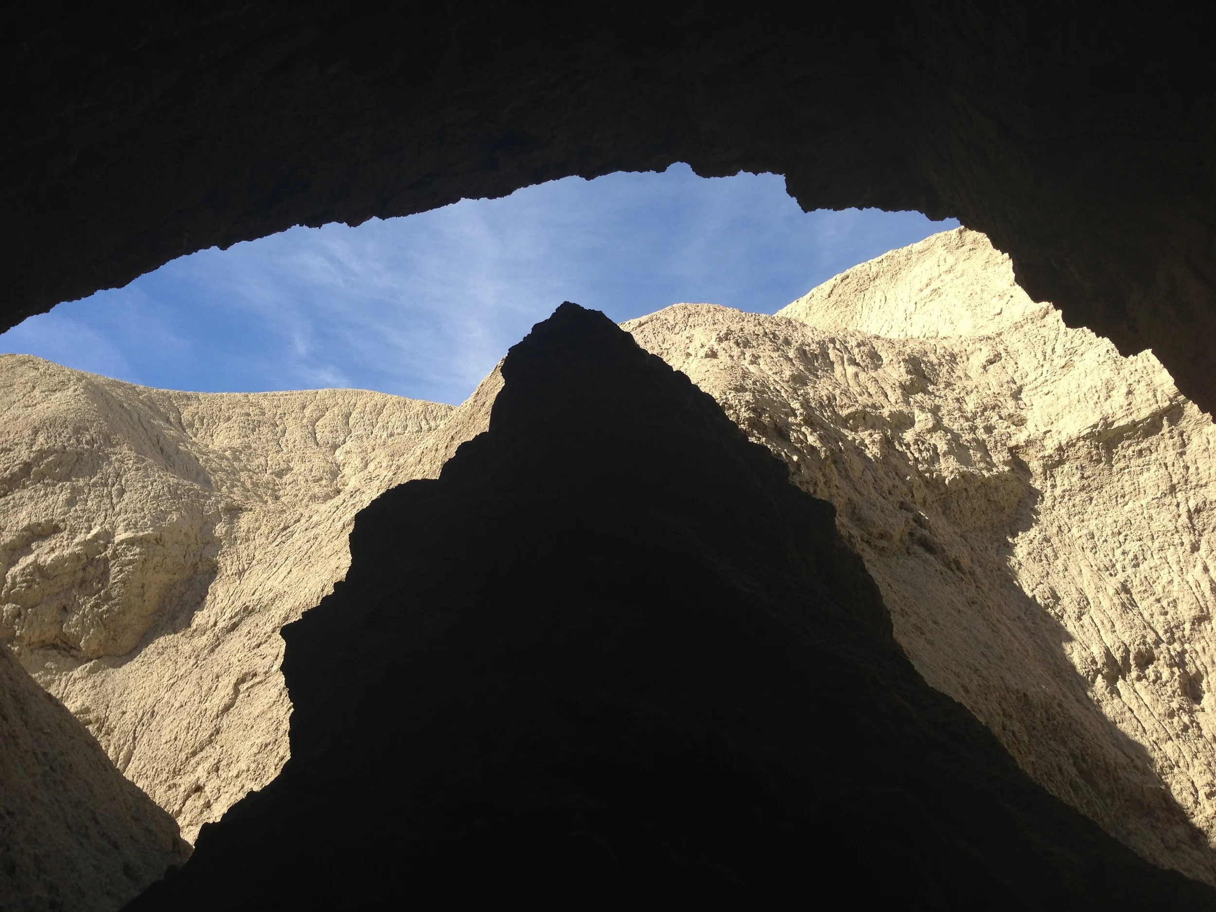
If you’re a Southern California resident, and you’re looking for a challenge that is a little more exciting than Potato Chip Rock (a/k/a Mount Woodson), the adventure you’re looking for is the Arroyo Tapiado Mud Caves. Since I covered this area in detail back in 2011 here, I’m not going to go into excruciating detail today, because you can read the details here. The caves are located approximately two hours outside of San Diego, and are perhaps the largest network of mud caves in the world, comprising some twenty to thirty caves.
Directions: If you are coming from San Diego, take the I-8 east to the town of Ocotillo, California. Exit the freeway, and turn onto the S-2 hearing North (Left). Follow the S-2 past the brand sparkling new wind turbines, through the border checkpoint, and into Anza-Borrego State Park. Once you are in the State Park, you will want to look for Mile Marker 43, which is also marked as the “Palm Spring” turnout (no, it is not the turnout for the town, it is the turnout for the actual Palm Spring from the Butterfield Stage Line). From this point on you will be “off-roading”.
Missing Hiker Found Dead in the Arroyo Tapiado
A couple of days ago, I was talking to a friend of mine, and she casually mentioned that the body of Guillermo Pino was found "in some caves somewhere in the desert". At the time, I didn't know what she was talking about - I hadn't heard of Guillermo Pino, and her description of the area -"some caves" was incredibly vague. I had some theories, however, and after a few questions I realized we were talking about the Arroyo Tapiado Mud Caves, an area I am fairly familar with, and an area I talked about earlier this year (http://lastadventurer.com/last-adventurers-fieldnotes/2012/1/3/the-arroyo-tapiado-mud-caves.html), and an area I was most recently in a year ago. When I got back home, I searched the internet and found out that Guillermo Pino did indeed go missing in the Arroyo Tapiado Mud Caves, and that his body was indeed found there recently. (http://cavingnews.com/20120507-body-of-missing-hiker-found-in-crevice-arroyo-tapiado-mud-caves, http://ramona.patch.com/articles/guillermo-pino-body-in-anza-borrego-cave-successfully-removed-identification-pending, http://blogs.laweekly.com/informer/2012/05/guillermo_pino_missing_anza-bo.php).
Obviously, at a time like this, one first feels enormous sympathy for the deceased's family, and for the deceased himself - this is a tragedy for all of them, and a very sad day for the hiking community in general. The lesson to take from all of this, however, is to always recognize the risks attendent in outdoor activities, and to always be properly prepared for whatever adventure you are attempting. In this respect, its always a good idea to have someone with you, and if you don't have someone with you, have left a detailed plan of where you are going, when you will be back, and possibly to have some sort of portable beacon (GPS or otherwise, such as SPOT: http://www.findmespot.com/en/). The thing that stands out about Guillermo's death is my recollection of the Arroyo Tapiado last year. I remember my friend Jaime and I explored a number of caves; and that the caves closest to the "parking area" were somewhat busy with people (somewhat busy meaning that there was minimal foot traffic going in both directions). But as we delved deeper into the caves, into chambers and other areas off the beaten path, there were no other visitors. At that point, it could have been easy to get lost - and this was in conditions that were pretty much optimal (warm day, other cave visitors).
The end result of this is that sadly, as mentioned above, a young man is dead. The other end result is that traffic to this area - the Arroyo Tapiado - will increase. While thats a macabre thing to say, it is also true. This is an area that has become more popular over the last five years as more people have become interested in outdoors activities, and now that it is in the news, the sensational aspect will no doubt attract more visitors ("hey, this is the cave that someone DIED in"). Disrespectful as it may be, this is how the world works. With this in mind, hopefully future visitors remember to take the necessary precautions needed for visits, and remember to be careful. Because, while the world is beautiful, as Guillermo noted, it is also dangerous, and the lesson we can take from his death - and honor his life - is to always be prepared when adventuring.
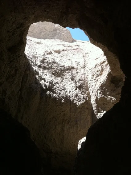
The Arroyo Tapiado Mud Caves

Entrance to one of the Arroyo Tapiado Mud Caves
Nothing says “exploring” like spelunking, unless you’re deathly afraid of the dark, bats, confined spaces, or were ever trapped in a cave/enslaved by Morlocks. If any of those things bother you, then caving/spelunking is not for you, and I don’t recommend it at all. Frankly, there’s no shame in not liking caving/spelunking, because in the dark, your mind and imagination can and will play all sorts of tricks as to what you perceive. I remember one time I was deep in a cave; then my light went out. In the sudden dark, I swore that I could hear footsteps paddling softly to my location. In my haste to get fresh batteries into my headlamp, I almost dropped them all over the ground, which would have been a disaster. Of course, once the new batteries were in the headlamp, there was nothing at all to be seen or heard, but to this day, I’d still swear that something was out there.

Yep, no lie - these caves are made of dried eroded mud!
Fortunately, the Arroyo Tapiado Mud Caves in Anza-Borrego State Park are not the fear-inducing type, as they are visited frequently by locals and travelers alike. You are more likely to be a few steps back from your fellow spelunkers than you are to discover something startling in these caves, which makes it a good location to practice your spelunking skills, should you be a novice. The caves are over five million years old, and are formed by erosion. Over the years, when it has rained, the water has cut into the hills, forming the various caves and channels that you can explore. The Arroyo Tapiado (meaning: mud-wall wash) Caves are some of the best preserved and most accessible caves in the world, so if you live in Southern California, this is yet another amazing feature that is accessible in a day’s drive or less.
Directions: From county road S-2 turn out at the signed Palm Spring turnoff. You will want to head down the road (note, this is a dirt road, and you will be off-roading. I’d recommend that if you are going to attempt this that you be in some sort of 4WD or AWD vehicle, although I have seen people make it out there in standard sedans – however, the road gets very soft and sandy, so if you get stuck in your non-4WD car, don’t say I didn’t warn you!) and bypass the spur road to Palm Spring (unless you want to check out the monument), and continue down Vallecito Wash. You can then park at the intersection of the road into Arroyo Tapiado, about four and one half (4.5) miles from S-2 and explore the area on foot.
Tips: Well, these are caves. And there’s a lot of them. You should have a flashlight, and if you’re smart, some sort of helmet. The helmet will protect your head from two things: falling mud, and falling bat poo. Not all caves have bats, but all bats have caves, so there’s a good chance you’ll run into some. Remember that they’re more scared of you then you are of them; and remember that they’re on the celling, so if you do startle them, there’s a high likelihood that they will poo on you, which is not pleasant. Did I mention that these caves are in the desert? They are! You’ll also want lots of water, since you’re in the desert, and since you’re exploring, you’ll probably want some sort of safety net – a buddy, or a rope or string to find your way out should you get lost.
Dry "waterfall" in the Arroyo Tapiado Cave System
I like to take a whole day to explore the area - there’s all sorts of neat canyons in addition to the caves, so there’s plenty of things to see and do. I’ve been told that there’s purportedly ancient fossils in the caves/cave area, but either I’m blind, or these fossils have been picked clean from the caves I’ve been in (FYI, you’re not supposed to remove them, should you find them). One last thing to be aware of: Southern California is a seismically active area, and earthquakes do occur on a regular basis. Additionally, these caves are made of mud, which is not the most stable of building materials even without earthquakes. While your odds of being trapped in a cave in are probably fairly low, you should be aware that the possibility does exist, so do take what precautions you can. Other than that, have a great time, and enjoy exploring!
The Blue Sun Cave
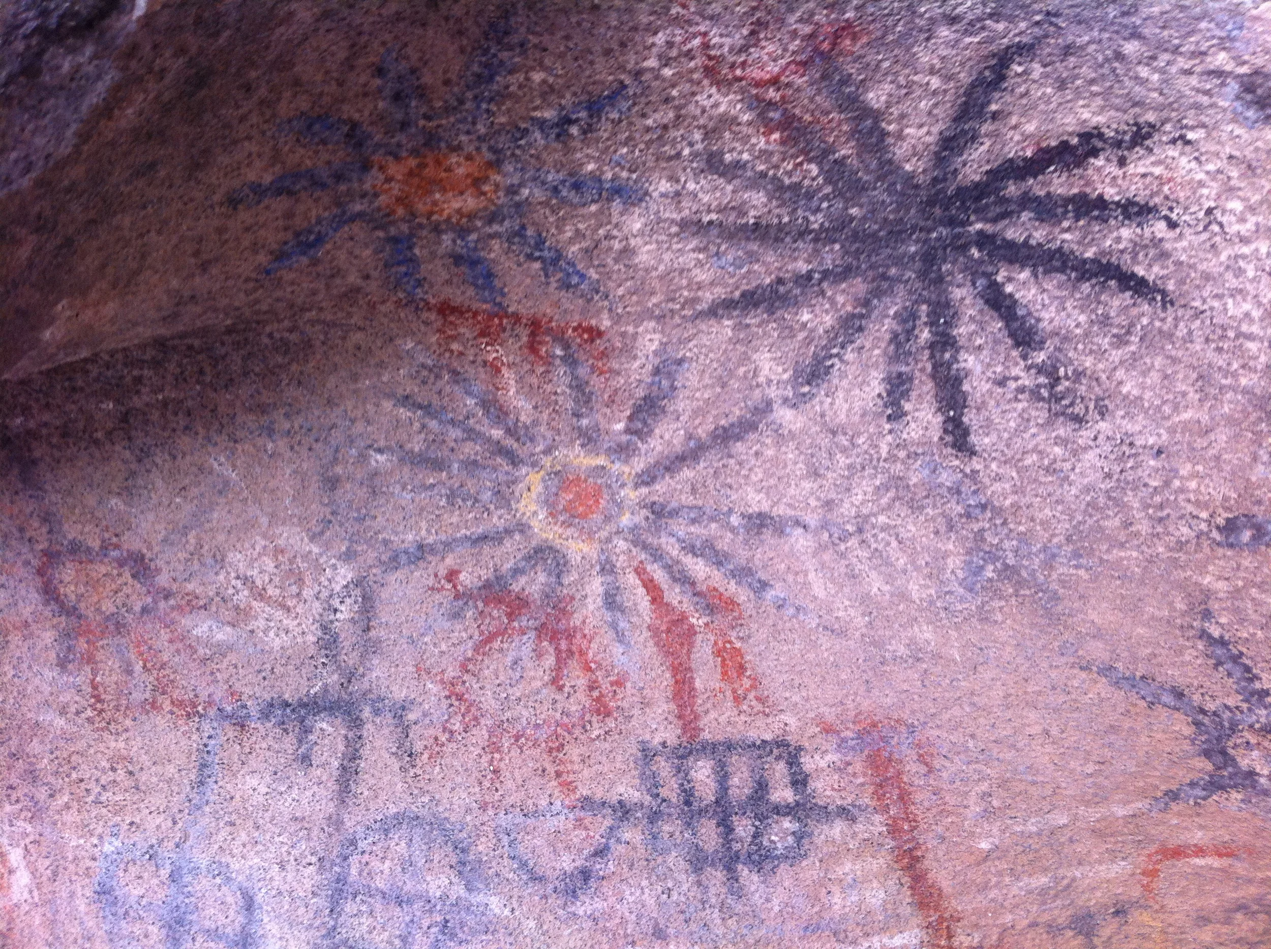
I can’t remember the first time I heard about the Blue Sun Cave. Maybe it was at a party, when I was discussing modern petroglyphs (graffiti) in the desert, compared to old, actual petroglyphs. Perhaps I stumbled across a mention of it online while searching for details on another trip. Or, maybe I read about it in my old, battered copy of Afoot and Afield in San Diego, by Jerry Schad. Even though I’m not sure how, where, or why I first heard about it, I do remember what Schad had to say about it, “rock art located on Indian Hill, which was purposely mislabeled on certain maps”.
Desert Oddities near the Blue Sun Cave, Anza Borrego Desert
As I'll discuss in detail tomorrow, sometimes it's not about the location, or how you get there, but the adventures you have trying to get there. I spent the better part of a month trying to find the Blue Sun Cave, and while at times I was frustrated, I had some great adventures trying to find it, and certainly saw some strange things. As I noted here: http://lastadventurer.com/last-adventurers-fieldnotes/2010/5/14/the-general-wastelands-are-not-lightly-traveledstories-and-t.html, any desert is not lightly traveled. But until I tell you about the Cave, check out what I did find over that month I spent looking (Including that sign that is featured in the link above!).
"Abandoned" Cargo Train, Dos Cabezas Siding
Part of the remaining structure of the Dos Cabezas rail station
Bouldering around the Dos Cabezas Region
And of course, lots of cacti - don't touch or pick up!Directions: Guess I should throw these up here should you want to try and find these things, right? You'll want to head nine to eleven miles West of Ocotillo, and you'll either need 4WD, AWD, a good mountain bike, or shoe leather. Pretty much all this is off the Dos Cabezas siding, or near there.