South Fortuna Mountain

South Fortuna Mountain

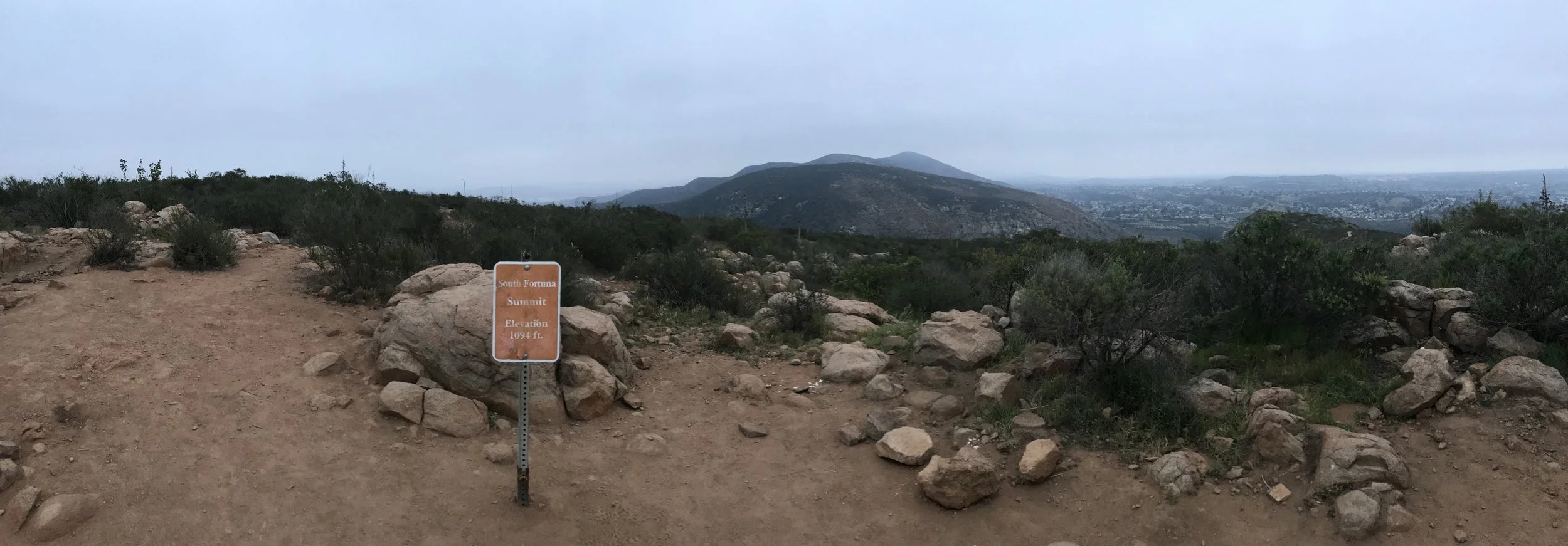
Mission Trails Regional Park is an area that is rich in pre-European history from the Kumeyaay people, and an area that is rich in post-European history with the Old Mission Dam along with the remnants of Camp Eliott. Within the confines of its 7,220 acres are five mountains, which comprise a hiking challenge for adventurous locals and visitors alike. However, a little known historic fact is that the park actually has four - not five mountains. Earlier maps of the region called both South Fortuna Mountain and North Fortuna Mountain simply “Long Peak”. Even today, from a distance, the separate summits of South Fortuna (1,094 feet elevation) and North Fortuna (1,291 feet elevation) separated by the Fortuna saddle appear to be one mass with a number of humps. Despite visual appearances and former maps, even though South Fortuna is the smallest summit in the park, it can be a great strenuous day hike, as part of a larger trek, or as a stand-alone summit.

San Jacinto - Tram to Summit

San Jacinto - Tram to Summit

San Jacinto Peak is the highest peak in the San Jacinto mountain range at 10,834 feet of elevation; and the second tallest mountain in Southern California. It is also the sixth most topographically prominent peak in the contiguous United States.In the past, San Jacinto was known to the Cahuilla Native Americans as Aya Kaich, meaning an area with smooth cliffs. To them, the mountain was the home to Dakush, the meteor and legendary founder of their tribe. Today, San Jacinto is known to hikers and mountaineers as one of the “Three Saints”, a term that refers to the three tallest mountain ranges in Southern California – the San Jacinto Range, the San Gabriel Range, and the San Bernadino Range. The other mountain members of the Three Saints are Mount San Antonio, and Mount San Gorgonio. The mountain has also been popular with modern explorers and conservationists, including John Muir, who stated, “The view from San Jacinto is the most sublime spectacle to be found anywhere on this earth”. The mountain is also a popular destination due to its proximity to Southern California, and has multiple points of access on both its Eastern flank (Palm Springs) and its Western Side (Idyllwild).

Mojave Memorial Cross

Mojave Memorial Cross

Along with abandoned mines and homesteads, a telephone booth, and at one point, a secret swimming pool, the Mojave Desert is, and has been full of interesting objects. Out of all these objects, the most controversial has been the White Cross World War I Memorial ("Mojave Memorial Cross"). Erected in 1934 to honor the veterans of World War I, the cross had an unremarkable life for roughly sixty years outside of Cima. However, at the end of the twentieth century, and the beginning of the twenty-first century, opponents of the cross mounted a number of legal challenges against the cross, stating that it violated the prohibitions in the Constitution regarding the separation of church and state, as it was on public (National Park Service) land.

Seventeen Mile Petroglyphs

Seventeen Mile Petroglyphs

Without a question, the Mojave National Preserve is one of the wildest units in the National Park system, as it spans over 1,600,000 acres of the Mojave Desert. In this vast area, visitors will find abandoned mines, abandoned homesteads, memorials, and a variety of other things. The park also has a number of rock art sites, ranging from the easy to find (along the Rings Loop Trail), and difficult to find, requiring four wheel drive, exploring and directions. In between the easy to find, and the hard to find is the rock art site commonly called "Seventeen Mile Petroglyphs". The site is named for the nearby Seventeen Mile point in the park; and does have some rock art. Having said that, the site is somewhat difficult to locate, and the rock art along the wash in part, has been defaced, or supplemented by additional drawings, leaving the visitor to wonder which drawings are real, and which are modern. Having said that, attempting to find the rock art is a great adventure for those visiting the Mojave National Preserve for a first time, or repeat visit.

Amboy Crater

Amboy Crater

For those that have never visited a desert, there is a popular perception that such areas only have miles and miles of flat, featureless terrain. In reality, however, deserts have a huge variety of terrain, ranging from mountains, sand dunes, slot canyons, sunken basins, and a variety of things in between. One of the most interesting things about deserts is that many of them provide evidence of dormant volcanism (such as the Ubehebe Crater), and active volcanism (such as the Mud Pots in the Salton Sea). In the Mojave Desert, there are a number of locations that one can see evidence of dormant volcanism, from the Cinder Cone area within Mojave National Preserve, and the Amboy Crater National Natural Landmark.

Ryan Mountain

Ryan Mountain

Joshua Tree National Park is renown for its signature tree, and for its rock climbing routes. Interspersed through the park, however, are some excellent hiking trails. Although a lot of “hiking” occurs within the confines of the campgrounds, and to and from climbing routes, the most popular trail is the park’s second highest mountain, Ryan Mountain. At a glance, the 5,456 foot tall mountain does not appear to be a challenging hike; especially as it is only one and a half miles to the summit, but with over one thousand feet of elevation gain, along with a number of other desert factors, this trail, and hike is not to be underestimated. But, for those hikers willing to brave the conditions, and at times, the crowds, the payoff for this hike is a desert summit with great three hundred and sixty degree views. 

Eagle Cliff Mine

Eagle Cliff Mine

Prior to being National, State, and other protected public lands, California’s eastern deserts were honeycombed with a variety of mining claims. While some of these claims were more successful than others, all of these claims had a variety of unique structures, and methods to extracting minerals. Today, many of these structures have disappeared, or have been closed off by various governmental agencies. Those that remain, fall into a number of categories ranging from easily found and known about (such as Bodie State Park), or unknown and visited, to known or unknown and closed off (such as Carey’s Castle in Joshua Tree National Park). The first and third categories are easily dealt with, as they provide explorers and visitors with clear direction. The second category, however, provides writers with difficulty in both reporting, and describing them, but in general, my approach to such things is to provide information, as they are on public land, and the best way to preserve them is to allow people to appreciate them and experience them.